

Embrace the Adventure, Conquer the Challenge!
Lake of the Ozarks Endurance Runs
2025 Race Notes (first note LOZ Traverse,
Second note Trail of Four Winds and Wandering Bobcat)

LOZ Traverse – 2026 Race Note
Runner To-Do List
-
Sign and return attached USATF waiver to HaHaRacingEvents@gmail.com
-
Don’t worry about the bib number or sanction number—just complete all other fields, and be sure to sign and date it. Do this today if possible.
-
-
Download course map onto your GPS watch if possible (cell service is spotty in the park). This is the best way to stay on course.
-
Carefully study course map and read through the entire race note
Quick Highlights
-
Packet pick-up is race day (May 2) only (6:00–7:00 a.m.)
-
USATF waiver required — no exceptions
-
Cupless event
-
No gels or salt tablets at aid stations (If these are important to you, please bring your own)
Packet Pick-Up
Race day only: 6:00–7:00 a.m.
Location: Start/finish line at Lake of the Ozarks State Park
Map: https://maps.app.goo.gl/xqvQC9CoJuQgGWQPA
Start/finish has been moved closer to the beach — a flatter, more scenic location.
Start Time
7:00 a.m.
Camping & Finish Line Hangout
Nearly a third of the field is camping within walking distance.
A food truck may be on site — bring payment if interested.
Be self-sufficient and bring chairs, coolers, and snacks so you can relax and enjoy the post-race atmosphere while watching runners finish.
Other Accommodations
There are many rental options for lodging at Lake of the Ozarks. If you're looking for a place somewhat close to the start/finish, check out the Holiday Inn Express in Osage Beach:
https://tinyurl.com/55mspz4v
Course Overview
-
2,800+ ft elevation gain
-
Rugged Ozark terrain: rocks, roots, uneven trail
Course Map: https://www.strava.com/activities/14369443506
Course Markings
-
Orange ribbon or surveyor flags (always on your right, except out-and-back sections where markings will be on both sides of the trail)
-
Orange cones near start/finish
-
Directional signage
Aid Stations
-
Mile 3.5
-
Mile 10
-
Mile 13.5
-
Mile 22 / 26.5 / 29 (LOZ Traverse only)
-
Finish
All stations include:
-
Electrolyte
-
Water
-
Assorted food
Do not skip the first aid station; otherwise, it will be 10+ miles before you reach the next one.
Cupless event
LOZ Traverse Details
-
Run full Trail of Four Winds 25K course and cross the finish line
-
Continue to Public Beach #1 transition area
-
Paddle to Passover Beach and check in with the check-in captain
Road Section: Passover Beach to Honey Run Trailhead
-
Take Passover Road (gravel) from Passover Beach to McCubbins Drive
-
Turn left on McCubbins Drive (asphalt)
-
Follow McCubbins Drive to Honey Run Trailhead on the right
-
This section (Passover Road + McCubbins Drive) is approximately 1.5 miles
Honey Run Trail System
-
Enter Honey Run Trail, run the approximately 3 mile section (singletrack) to check-in captain
-
Run North Loop (clockwise) → return and check in
-
Run South Loop (clockwise) → return and check in
-
Exit via same trail back to McCubbins Drive
-
Turn left on McCubbins Drive
-
Turn right on Passover Road
-
-
Return to Passover Beach and check in
-
Put life jacket back on
-
Paddle back across the lake
-
Run across finish line
Key Requirements
-
Bring your own kayak/canoe
-
USCG-approved life jacket required
-
One person per boat
-
No outside assistance or pacers.
Checkpoints
-
Passover Beach: check in 2 times
-
Honey Run: check in 3 times
Road/Gravel Section
Run against traffic at all times.
Race Shirts (may be delayed)
If so:
-
Shirts will be mailed to all runners
-
First 50 runners also receive a race mug (those will be mailed as well)
Contact
Kayak Rental Option
Need a kayak?
Paradise Marina and Watersports
1100 Bagnell Dam Blvd, Lake Ozark, MO 65049
+1 (573) 745-0700
-
Rental price: $75 (includes paddle and life jacket)
-
Must pick up and return yourself
-
Pick up by 3:00 p.m. Friday, May 1 (road closure on Bagnell Dam Strip after that time)
-
Return by Sunday at noon, May 3
-
Staff will load/unload kayak from your vehicle
-
First come, first serve — reserve early
-
Previous rental provider is no longer in business
Feel free to reach out with any questions. The race day weather is looking great. Safe travels, and we'll see you soon!
Note Pics (below all race notes):
-
Start/Finish Line Map
-
Examples of orange ribbon and directional signage (orange surveyor flags and orange cones will be used as well)
-
Photo of the dog on McCubbins Drive: This dog acts aggressive at times, but it has always stopped at the road in the past.
Trail of Four Winds 25K & Wandering Bobcat 5 Miler – 2026 Race Note
Runner To-Do List
-
Sign and return attached USATF waiver to HaHaRacingEvents@gmail.com
-
Don’t worry about the bib number or sanction number—just complete all other fields, and be sure to sign and date it. Do this today if possible.
-
-
Download course map onto your GPS watch if possible (cell service is spotty in the park)
-
Carefully study course map and read through the entire race note
Quick Highlights
-
Packet pick-up is race day only
-
USATF waiver required — no exceptions
-
Cupless event
-
No gels or salt tablets at aid stations (If these are important to you, please bring your own)
Packet Pick-Up
Race day only: 7:00–9:30 a.m.
Location: Start/finish line at Lake of the Ozarks State Park
Map: https://maps.app.goo.gl/xqvQC9CoJuQgGWQPA
Start/finish is closer to the beach this year — a flatter, more scenic setup.
Start Times
-
Trail of Four Winds 25K: 9:00 a.m.
-
Wandering Bobcat 5 Miler: 9:30 a.m.
Camping & Finish Line Hangout
Many runners are camping within walking distance of the start/finish.
A food truck may be on site — bring payment if interested.
Be self-sufficient and bring chairs, coolers, and snacks so you can relax and enjoy the post-race atmosphere at the beach while watching runners finish.
Other Accommodations
There are many rental options for lodging at Lake of the Ozarks. If you're looking for a place somewhat close to the start/finish, check out the Holiday Inn Express in Osage Beach:
https://tinyurl.com/55mspz4v
Course Overview
Trail of Four Winds 25K
-
1,600+ ft elevation gain
-
Technical Ozark terrain
-
Course Map: https://www.strava.com/activities/14366932469
Wandering Bobcat 5 Miler
-
Closer to 5.5 miles
-
700+ ft elevation gain
-
Course Map: https://www.strava.com/activities/16236718499
Course Markings
-
Orange ribbon or surveyor flags (always on your right, except out-and-back sections where markings will be on both sides of the trail)
-
Orange cones near start/finish
-
Directional signage
Course Notes
Trail of Four Winds 25K
At approximately mile 3.5 (first aid station):
-
25K runners veer right
Wandering Bobcat 5 Miler
At approximately mile 3.5 (first aid station):
-
Bobcat runners veer left back to finish
Aid Stations
Trail of Four Winds 25K
-
Mile 3.5
-
Mile 10
-
Mile 13.5
-
Finish
Wandering Bobcat 5 Miler
-
Mile 3.5
-
Finish
All aid stations include:
-
Electrolyte
-
Water
-
Food
Cupless event
Race Shirts (may be delayed)
If so:
-
Shirts will be mailed to all runners
-
First 50 runners also receive a race mug (those will be mailed as well)
Contact
Feel free to reach out with any questions. The race day weather is looking great. Safe travels, and we'll see you soon!
Pictures:
-
Start/Finish Line Map
-
Examples of orange ribbon and directional signage (orange surveyor flags and orange cones will be used as well)
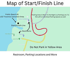
Start/Finish Line Map (All Races)

Orange Ribbon Trail Marker

Directional Signage Four Winds Side
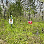
Directional Signage LOZ Traverse Side
